Month: December 2025

  • Recovery After the Western Washington Floods: What Residents Can Do Now (and How Communities Can Help)

    Recovery After the Western Washington Floods: What Residents Can Do Now (and How Communities Can Help)

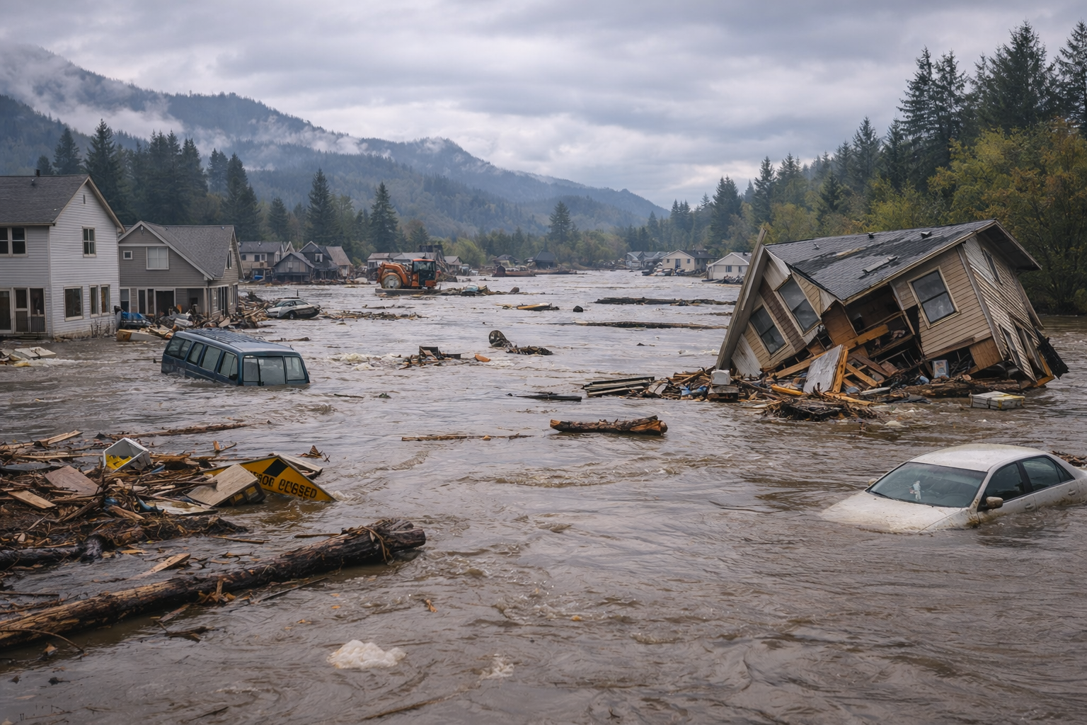
    When floodwaters recede, the hardest part often begins: documentation, cleanup, temporary housing, insurance, and navigating local/state/federal assistance pathways. For Western Washington’s December 2025 flooding, several steps are consistently recommended by emergency management organizations and state leaders.

    Step 1: Safety first—avoid secondary hazards

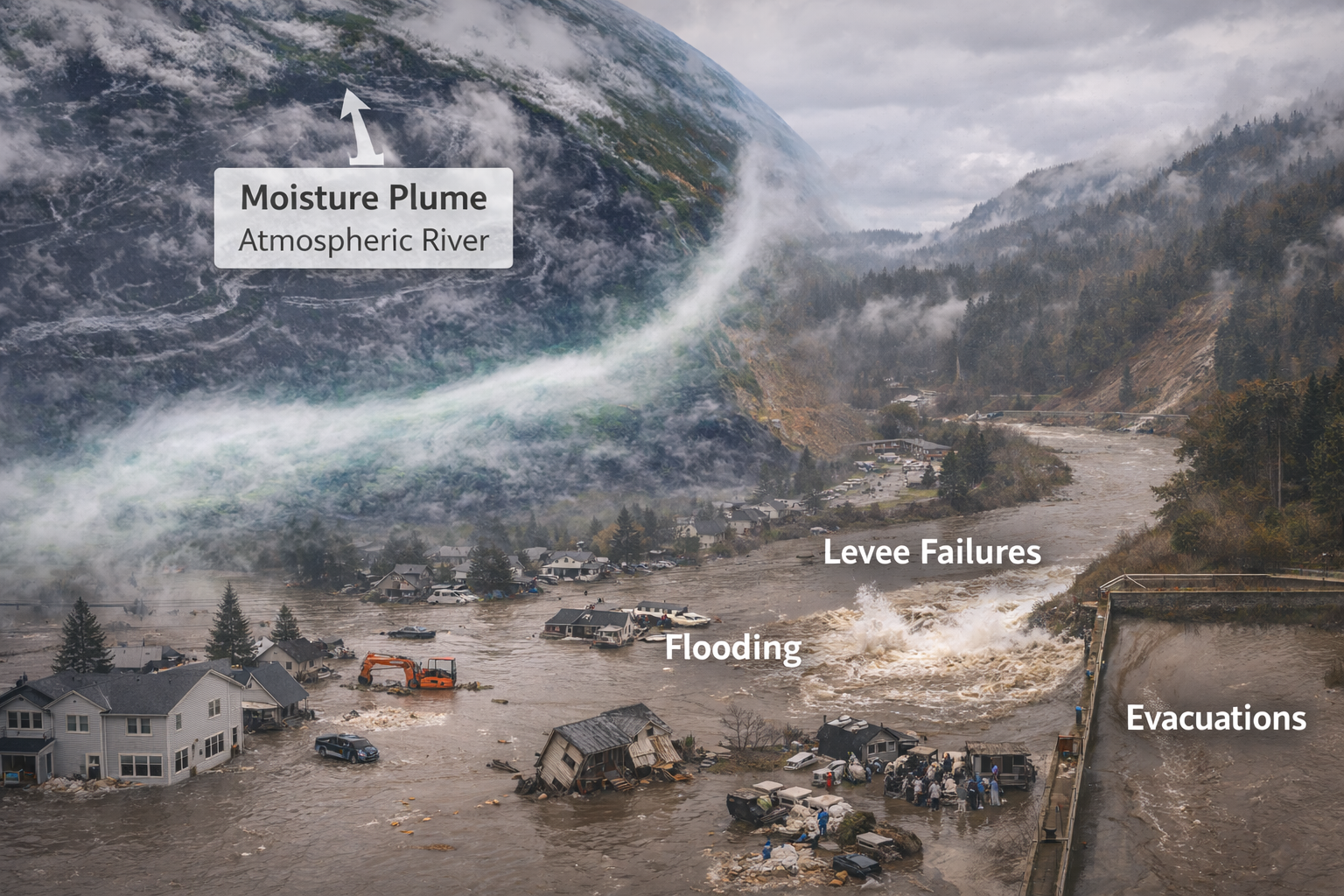
    Even after rain eases, hazards remain:

    • Standing water can conceal washed-out roads and fast currents.

    • Saturated slopes can fail days later.

    • Downed power lines and damaged utilities can create life-threatening risks.

    This event included fatal risk-taking outcomes; local reporting emphasized the danger of driving into flooded roadways and the importance of heeding closures. People.com

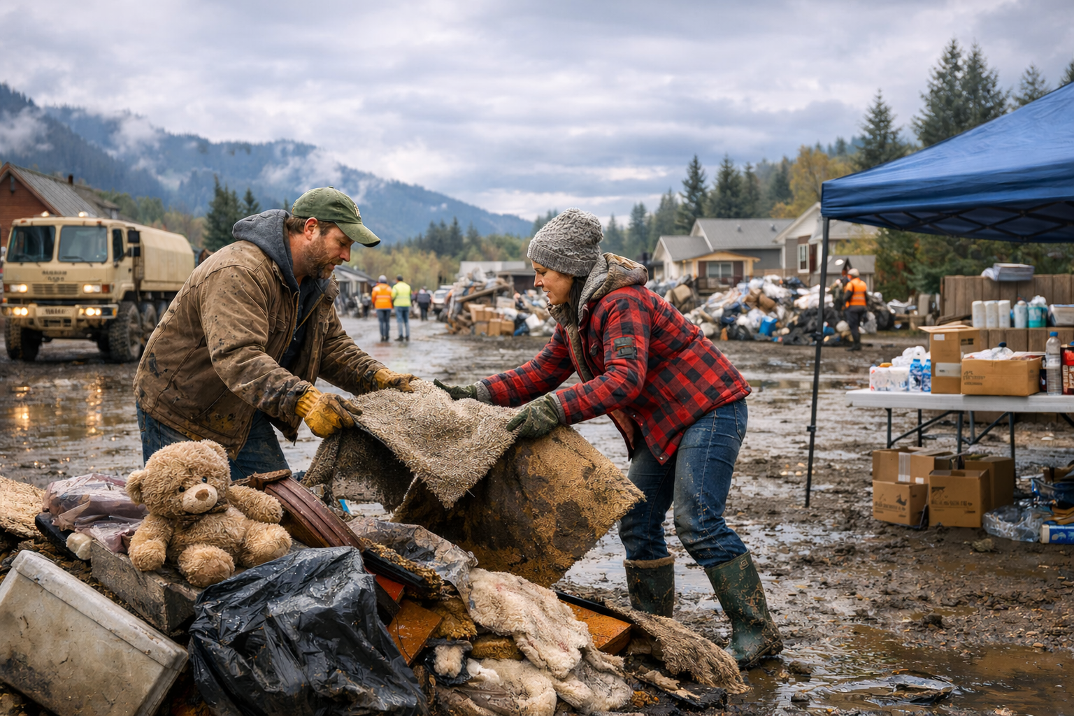
    Step 2: Document damage immediately and thoroughly

    If you are affected:

    • Photograph and video all impacted areas before cleanup, if it is safe.

    • Save receipts for emergency repairs, lodging, fuel, supplies, and cleanup materials.

    • Write down dates/times of impacts, evacuations, and interactions with officials.

    This documentation becomes critical for insurance claims, state assistance, and potential FEMA-related programs if expanded declarations occur.

    Step 3: Report impacts through official county/state channels

    In many disasters, aggregated local reporting helps determine eligibility and scope for additional resources. FOX 13 Seattle noted that residents in multiple counties were being asked to report flood impacts as officials assess damages and the potential for broader federal assistance. FOX 13 Seattle

    Step 4: Track state and federal assistance status

    Two authoritative places to monitor:

    • Washington Governor’s office for proclamations and activated aid programs (including the announced $3.5 million support across 14 counties). Washington Governor’s Office

    • FEMA’s Washington incident listings, including the emergency listing that began December 9, 2025 and continues. FEMA

    As declarations evolve, assistance types can change (temporary housing, individual assistance, public assistance, hazard mitigation). Until a specific program is confirmed for your area, avoid relying on rumors and focus on official announcements.

    Step 5: Expect transportation disruptions to influence recovery

    Flood recovery is slower when:

    • primary routes remain closed,

    • detours are long or unstable,

    • supply chains and contractors can’t reach affected areas efficiently.

    King County’s road closure tools and storm updates are practical sources for “day-to-day reality” during recovery. King County+1
    For longer disruptions, the US-2 Stevens Pass closure timeline reported by Washington State Standard is an example of how infrastructure damage can become a months-long constraint. Washington State Standard

    How community organizations can help effectively

    For Rotary clubs, nonprofits, and community networks, the most effective support usually falls into five categories:

    1. Damage reporting and navigation support: help residents understand how to report impacts and keep documentation organized. FOX 13 Seattle

    2. Cleanup logistics: volunteer coordination, debris removal support, tool lending, supply drives.

    3. Short-term relief funding: flexible, rapid microgrants for lodging, food replacement, fuel, cleanup supplies—especially for those waiting on insurance timelines.

    4. Case management partnerships: align with county emergency management, local food banks, and established relief organizations to avoid duplicative or misdirected aid.

    5. Transparent public updates: publish what’s been raised, where it went, and what the next priority needs are.

  • What We Know About Damage and Disruption So Far in Western Washington’s December 2025 Flooding

    What We Know About Damage and Disruption So Far in Western Washington’s December 2025 Flooding

    While damage assessments continue to evolve, reporting and official updates already show a consistent picture: widespread inundation in lowlands, major transportation interruptions, hundreds of rescues, and a recovery timeline that will extend well beyond the storm window.

    Rescues and evacuations: scale of immediate life-safety impacts

    The Associated Press reported that Washington’s governor described 629 rescues and 572 assisted evacuations amid the flooding and storm impacts, with evacuation orders affecting large populations in flood-prone areas. AP News

    These figures matter because they indicate the event wasn’t limited to nuisance flooding; it involved widespread, active emergency operations.

    Levee failure on the Green River corridor

    On December 15, a levee breach along the Green River triggered urgent evacuation warnings for parts of Tukwila, Kent, and Renton. Reuters and Axios both reported the immediate response—sandbagging, sheltering, and warnings that access routes could become impassable quickly. Reuters+1

    This corridor is particularly sensitive because it combines residential areas, industrial facilities, and key transportation links.

    Roads, highways, and mobility: the “second disaster”

    Flood response is only as effective as access routes allow. Multiple reports highlighted extensive closures and disruptions:

    • KING 5 covered ongoing landslides, closures, and flood impacts across Western Washington. KING 5

    • The Washington State Standard reported that a major closure on US-2 across Stevens Pass was expected to last months, underscoring how slope failures and roadway damage can become long-duration disruptions. Washington State Standard

    • King County published real-time road closure updates and storm response communications, which are often the most operationally reliable sources for “what is actually passable right now.” King County+1

    Federal emergency action and state financial support

    From a recovery standpoint, two developments are particularly important:

    1. FEMA emergency declaration status: FEMA lists an event titled “Washington Severe Storms, Straight-line Winds, Flooding, Landslides, and Mudslides,” with an emergency designation beginning December 9, 2025, and continuing. FEMA

    2. Washington State response funding: Governor Bob Ferguson’s office announced amendments to emergency proclamations and directed $3.5 million in support across 14 impacted counties to speed emergency assistance. Washington Governor’s Office

    These actions often shape how quickly local governments and nonprofits can stabilize impacted residents—especially when housing displacement, debris removal, and infrastructure repair start to dominate.

    Environmental and community impacts beyond homes and roads

    Flooding doesn’t only damage buildings; it can also severely affect public lands, fish and wildlife habitat, and access sites. Regional reporting on impacts to salmon and recreational infrastructure—such as damage around ramps and staging areas—shows the event’s reach into ecosystems and community resources.

  • Western Washington’s December 2025 Floods Were Not “Just Heavy Rain.” Here’s What Actually Happened.

    Western Washington’s December 2025 Floods Were Not “Just Heavy Rain.” Here’s What Actually Happened.

    In early-to-mid December 2025, Western Washington experienced one of its most consequential flood episodes in years—driven by a sequence of atmospheric rivers that delivered extraordinary precipitation, rapidly elevated rivers, and triggered levee failures, landslides, and widespread evacuations. NASA Science+2AP News+2

    What an “atmospheric river” meant this time

    Atmospheric rivers are long, narrow corridors of concentrated water vapor that can transport immense moisture from the Pacific into the West Coast. In this event, multiple waves of Pacific moisture targeted the region over several days, producing prolonged, intense rainfall and compounding impacts as soils saturated and rivers had little capacity to absorb additional runoff. NASA’s Earth Observatory documented the moisture plume and noted that the heaviest impacts began around December 7, 2025, with flooding and landslides following as rainfall persisted. NASA Science

    Record water volumes in a short window

    One of the most useful ways to understand the scale is to translate rainfall into volume. KUOW analyzed rainfall over a 10-day period in December 2025 (Dec. 9–19) across 17 watersheds east of Puget Sound—from the Nooksack basin south to the Lewis—and estimated roughly nine million acre-feet of water fell in that span (not statewide totals, but specifically across those watersheds). KUOW

    That magnitude helps explain why “normal” flooding safeguards became strained: the issue wasn’t one peak day, but repeated pulses of heavy precipitation layered onto already saturated ground.

    Rivers hit levels that communities plan around—and beyond

    As the storms lined up, multiple rivers in Western Washington reached major flood stages, with some gauges meeting or exceeding historical crests.

    • FOX 13 Seattle reported the Snoqualmie River at Snoqualmie Falls reached 17.88 feet on Dec. 9, edging above a prior high of 17.85 feet (Oct. 22, 2020). FOX 13 Seattle

    • The Weather Channel also summarized several key crests and noted that major rivers continued rising even as rainfall briefly eased, a classic lag effect when upstream basins drain into mainstem rivers. The Weather Channel

    Levees and lowlands: when water meets infrastructure limits

    Flooding becomes dramatically more dangerous when river systems overtop or breach flood control structures. On December 15, flash flood warnings and “go now” evacuation orders followed a breach along the Green River’s Desimone Levee area, affecting parts of Tukwila, Kent, and Renton (with shelters opening in the area). Reuters+1

    Reuters reported the breach washed away a car-sized section and prompted emergency sandbagging operations. Reuters

    Why this flood was so disruptive

    Flood disasters are rarely one single hazard. This event stacked multiple risk layers at once:

    1. Hydrology risk: rapid rises on rivers and tributaries. The Weather Channel+1

    2. Geology risk: landslides and debris flows with saturated slopes and intense rain. KING 5+1

    3. Infrastructure risk: levee stress, road washouts, and closures limiting evacuation routes and emergency access.